 Load Series
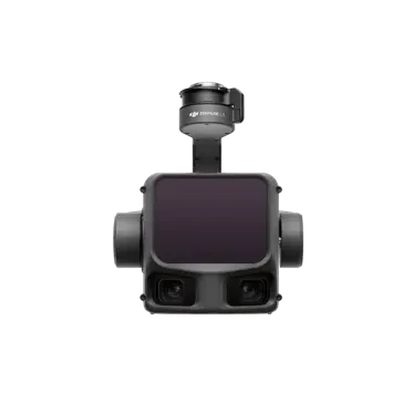
Zenmuse L3
Next-generation airborne high-precision mapping LiDAR system equipped with a 1535 nm long-range LiDAR featuring strong penetration capability. Integrated with dual 100-megapixel visible-light cameras and a high-precision pose system, it works seamlessly with the D-RTK 3 multi-functional base station and DJI Terra to deliver a complete aerial survey workflow from data acquisition to post-processing.
Core Specifications
Product Video Introduction
Video sourced from the official DJI product page for reference.Zenmuse L3appearance and core functionality
* The video is an official DJI product video for reference on product form and features; actual configuration and pricing are subject to inquiry results.
Full Specifications
| Product Name | Zenmuse L3 |
| Point Cloud System Accuracy | 120 m flight altitude: Elevation 3 cm, Horizontal 4 cm (RMSE) 300 m flight altitude: Elevation 5 cm, Horizontal 7.5 cm (RMSE) |
| Point Cloud Thickness | 1.2 cm @ 1σ (120 m GSD) | 2 cm @ 1σ (300 m GSD). In single-line repeat scan mode, using a target with 80% reflectance as the checkpoint. DJI Terra point cloud accuracy optimization and decimation were not applied. 6σ thickness must be multiplied by 6. |
| Dual visible-light horizontal field of view | 107° synthesized from two cameras with an optical axis angle of 45° |
| Visible Light Ground Sampling Distance (GSD) | Average: 3 cm (300 m nadir). For detailed calculation methods, see the user manual on the DJI Zenmuse L3 official download page. |
| Weight | 1.60 kg (excluding Zenmuse L3 gimbal unit); Zenmuse L3 gimbal unit weighs 145 g |
| Size | Length: 192 mm, Width: 162 mm, Height: 202 mm. Non-orthogonal gimbal; this dimension reflects the default stabilized state upon startup. |
| System Power Consumption | 64 W (typical) 100 W (max) |
| Supported Models | DJI Matrice 400 (requires Zenmuse L3 gimbal) |
| Protection Rating | IP4 |
| Operating Temperature | -20°C to 50°C |
| Storage Temperature | -40°C to 70°C |
| LiDAR · Laser Wavelength | 1535 nanometers |
| LiDAR · Laser Divergence Angle | 0.25 mrad (1/e²) |
| LiDAR · Laser Spot Size | Φ 41 mm @ 120 m (1/e²) Φ 86 mm @ 300 m (1/e²) |
| LiDAR · Range | 700 m @ 10% reflectivity, 350 kHz; 950 m @ 10% reflectivity, 100 kHz; 2000 m @ 80% reflectivity, 100 kHz; 1. Range definition: the distance at which 50% of transmitted pulses are detected. If a laser beam hits multiple targets, energy is split and range may decrease. 2. Test conditions: 100 klx ambient light, center of field of view, 23 km atmospheric visibility, flat target larger than the laser beam diameter, with laser incidence perpendicular to the target plane. 3. By default, maximum measurement distance is 900 m. For extended range, contact technical support or an authorized distributor. |
| LiDAR · Wire Range | Diameter 21.6 mm ACSR: 300 m @100 klx, 350 kHz; Diameter 18.4 mm black insulated wire: 100 m @100 klx, 350kHz 1. Range definition: The distance at which a segment of wire fully scanned during mapping achieves a point density of 4 points/m. 2. Test conditions: 100 klx ambient light, 23 km atmospheric visibility, LiDAR center FOV perpendicular to the cable, non-repetitive scanning mode, UAV flying along the wire at 15 m/s, clean and non-aged wire. |
| LiDAR · Range Accuracy | Absolute accuracy: ±10 mm; Repeatability: < 5 mm (1σ). These specifications are met under the following test conditions: ambient temperature 25°C, radar frequency 350 kHz, target reflectivity 80%, and distances of 120 m and 300 m. Actual values may vary based on specific test conditions; refer to actual measurements for precise figures. |
| LiDAR · Minimum Effective Detection Range | 10 meters |
| LiDAR · Laser Pulse Emission Frequency | 100 kHz, recommended flight altitude < 500 m 350 kHz, recommended flight altitude < 300 m 1000 kHz, recommended flight altitude < 100 m 2000 kHz, recommended flight altitude < 50 m |
| LiDAR · Echo Count | 4, 8, 16 echoes (100 kHz, 350 kHz) 4, 8 echoes (1000 kHz) 4 echo (2000 kHz) |
| LiDAR · Cross-Period Calculation | 7 times |
| LiDAR · Scan Modes and Field of View | Linear repeat scan: Horizontal 80°, Vertical 3° X-pattern repeat scan: Horizontal 80°, Vertical 80° Non-repeat scan: Horizontal 80°, Vertical 80° |
| LiDAR · Laser Safety Class | Class 1 (IEC 60825-1:2014) |
| Surveying Camera · Sensor | Sensor format: 4/3 CMOS |
| Survey Camera · Lens | Focal length: 28 mm | Field of view: 73.3° (diagonal), 62° (horizontal), 41.2° (vertical) | Aperture: f/2.0 to f/11 |
| Survey Camera · Shutter | Mechanical Shutter: 2 to 1/1500 sec (f/2.0), 2 to 1/2000 sec (f/2.8 to f/11) | Shutter Life: 50 million actuations Electronic Shutter: 2 to 1/16000 sec |
| Survey Camera · Photo Specifications | 100 million pixels: 12288 × 8192 2500 thousand pixels: 6144 × 4096 |
| Survey Camera · Minimum Photo Interval | JPEG: 2500 megapixels, 0.5 seconds; 100MP: 1 seconds; RAW or JPEG + RAW: 1.2 seconds |
| Survey Camera · Video Specifications | Video Format: MP4 (MPEG-4 HEVC/H.265) Resolution: 4K: 3840 × 2160@30fps FHD: 1920 × 1080@30fps |
| Pose System · GNSS Update Frequency | 5 Hz |
| Pose System · POS Update Frequency | 200 Hz |
| Pose System · Attitude Error | Yaw: 0.02° (post-processed, 1σ) | Pitch/Roll: 0.01° (post-processed, 1σ) |
| Pose System · Positioning Accuracy | Horizontal accuracy: 1.0 cm + 1 ppm (RTK fixed). Vertical accuracy: 1.5 cm + 1 ppm (RTK fixed). |
| Pose System · PPK-Supported Differential Data Formats | DAT: D-RTK 3 Multi-functional Base Station, RINEX: v2.1x, v3.0x RTCM: v3.0, v3.1, v3.2, v3.3 (MSM3, MSM4, MSM5, MSM6, MSM7 protocols), OEM: OEM4, OEM6 in base station mode of D-RTK 2. During field operations, ensure the distance between the base station and aircraft is within 15 km, and the base station must track satellites from more than two systems. |
| Gimbal Parameters · Degrees of Freedom | Three-axis (pitch, roll, yaw) |
| Gimbal Parameters · Angular Precision | ±0.01° |
| Gimbal Parameters · Mechanical Angle Range | Pitch: -135° to +73°, Roll: -90° to +60°, Yaw: -105° to +105° and above |
| Pan Parameters · Controllable Rotation Range | Pitch: -120° to +60°, Yaw: -80° to +80°. Roll is uncontrolled and used for stabilization only. |
| Gimbal Parameters · Self-Test Method | Roll Axis: No Self-Check Required; Yaw Axis: Limit Switch Hit; Pitch Axis: No Self-Check Required |
| Pan/Tilt Parameters · Mounting Method | DJI SKYPORT Quick-Release (Zenmuse L3 Single Gimbal Module) |
| Data Storage · Raw Data Storage | Photos/IMU Point Cloud Data/GNSS Data/Calibration Files |
| Data Storage · Standard SD Card | CFexpress™ Type B memory card, sequential write speed 1500MB/s |
| Data Storage · Standard Card Reader | Read/Write Speed > 900MB/s |
| Software Ecosystem · Data Collection | DJI Pilot 2 |
| Software Ecosystem · Data Processing | DJI Terra |
| Software Ecosystem · Data Applications | DJI Terra |
| Software Ecosystem · Cloud Applications | DJI FlightHub 2 |
| Software Ecosystem · Data Formats | DJI Terra supports exporting point cloud models in the following standard formats: Standard point cloud formats: PNTS/LAS/LAZ/PLY/PCD/S3MB DJI Terra supports importing point cloud models in the following standard formats: Standard point cloud format: LAS |
* Specifications are sourced from DJI's official product page; actual configurations may vary by factory. Prices are subject to inquiry.
Download Product Brochure
Below isZenmuse L3Product Brochure Preview: Click the button to generate and download a PDF version for internal review and selection archiving.
The next-generation airborne high-precision photogrammetry LiDAR system features a 1535 nm long-range LiDAR with powerful penetration capabilities. It integrates dual 100-megapixel visible-light cameras and a high-precision pose system. Paired with the D-RTK 3 multi-functional base station and DJI Terra, it delivers a complete aerial survey solution from data acquisition to post-processing.
| Product Name | Zenmuse L3 |
| Point Cloud System Accuracy | 120 m flight altitude: Elevation 3 cm, Horizontal 4 cm (RMSE) 300 m flight altitude: Elevation 5 cm, Horizontal 7.5 cm (RMSE) |
| Point Cloud Thickness | 1.2 cm@1σ (120 m GSD) 2 cm@1σ (300 m GSD). In the single-pass scan mode, a target with 80% reflectance was used as a checkpoint. DJI Terra point cloud accuracy optimization and point cloud decimation were not applied. The thickness corresponding to 6σ must be multiplied by 6. |
| Dual visible light horizontal field of view | 107° synthesized from two cameras with an optical axis angle of 45° |
| Visible Light Ground Sample Distance (GSD) | Average: 3 cm (300 m nadir). For detailed calculation methods, see the user manual on the DJI Zenmuse L3 official download page. |
| Weight | 1.60 kg (excluding Zenmuse L3 gimbal unit); Zenmuse L3 gimbal unit weighs 145 g |
| Size | Length: 192 mm, Width: 162 mm, Height: 202 mm. Non-orthogonal gimbal; these dimensions represent the default stabilized state upon startup. |
| System Power Consumption | 64 W (typical) 100 W (max) |
| Supported Models | DJI Matrice 400 (requires Zenmuse L3 single-gimbal assembly) |
| Protection Rating | IP4 |
| Operating Temperature | -20°C to 50°C |
| Storage Temperature | -40°C to 70°C |
| LiDAR · Laser Wavelength | 1535 nanometers |
| LiDAR · Laser Divergence Angle | 0.25 mrad (1/e²) |
| LiDAR · Laser Spot Size | Φ 41 mm @ 120 m (1/e²) Φ 86 mm @ 300 m (1/e²) |
| LiDAR · Range | 700 m @ 10% reflectivity, 350 kHz; 950 m @ 10% reflectivity, 100 kHz; 2000 m @ 80% reflectivity, 100 kHz. 1. Range definition: The distance at which 50% of the emitted pulses are detected. If a laser pulse strikes multiple targets, the energy is distributed, which may reduce the range. 2. Test conditions: 100 klx ambient light, center of the field of view, 23 km atmospheric visibility, flat target larger than the laser beam diameter, with the laser incident perpendicular to the target plane. 3. By default, the maximum measurement distance is 900 m. For extended ranges, contact technical support or an authorized distributor. |
| LiDAR · Wire Range | Diameter 21.6 mm ACSR: 300 m@100 klx, 350 kHz; Diameter 18.4 mm black-jacketed cable: 100 m@100 klx, 350kHz 1. Range definition: Distance required to fully scan a segment of wire during mapping at a point density of 4 points/m. 2. Test conditions: 100 klx ambient light, 23 km atmospheric visibility, LiDAR center field of view perpendicular to the wire, non-repetitive scanning mode, drone flying along the wire at 15 m/s, with clean and unaged wires. |
| LiDAR · Range Accuracy | Absolute accuracy: ±10 mm; Repeatability: < 5 mm (1σ). These specifications are met under the following test conditions: ambient temperature 25°C, radar point frequency 350 kHz, target object reflectivity 80%, and distances of 120 m and 300 m. Actual values may vary based on testing conditions; please refer to actual measurements. |
| LiDAR · Minimum Effective Detection Range | 10 meters |
| LiDAR · Laser Pulse Emission Frequency | 100 kHz, recommended flight altitude < 500 m 350 kHz, recommended flight altitude < 300 m 1000 kHz, recommended flight altitude < 100 m 2000 kHz, recommended flight altitude < 50 m |
| LiDAR · Echo Count | 4, 8, 16 echoes (100 kHz, 350 kHz) 4, 8 echoes (1000 kHz) 4 echo (2000 kHz) |
| LiDAR · Cross-Period Calculation | 7 times |
| LiDAR · Scan Modes and Field of View | Linear repeat scan: Horizontal 80°, Vertical 3° X-pattern repeat scan: Horizontal 80°, Vertical 80° Non-repeat scan: Horizontal 80°, Vertical 80° |
| LiDAR · Laser Safety Class | Class 1 (IEC 60825-1:2014) |
| Surveying Camera · Sensors | Sensor format: 4/3 CMOS |
| Surveying Camera · Lens | Equivalent focal length: 28 mm. Field of view: 73.3° (diagonal), 62° (horizontal), 41.2° (vertical). Aperture: f/2.0 to f/11. |
| Survey Camera · Shutter | Mechanical Shutter: 2 to 1/1500 sec (f/2.0), 2 to 1/2000 sec (f/2.8 to f/11) Shutter Count: 50 thousand actuations Electronic Shutter: 2 to 1/16000 sec |
| Survey Camera · Photo Specifications | 100MP: 12288 × 8192 2500K MP: 6144 × 4096 |
| Survey Camera · Minimum Photo Interval | JPEG: 2500 MP, 0.5 sec; 100MP: 1 sec; RAW or JPEG + RAW: 1.2 sec |
| Survey Camera · Video Specifications | Video format: MP4 (MPEG-4 HEVC/H.265) Resolution: 4K: 3840 × 2160@30fps, FHD: 1920 × 1080@30fps |
| Pose System · GNSS Update Frequency | 5 Hz |
| Pose System · POS Update Frequency | 200 Hz |
| Pose System · Attitude Error | Yaw angle: 0.02° (post-processed, 1σ) Pitch/Roll angle: 0.01° (post-processed, 1σ) |
| Pose System · Positioning Accuracy | Horizontal Accuracy: 1.0 cm + 1 ppm (RTK Fixed) Vertical Accuracy: 1.5 cm + 1 ppm (RTK Fixed) |
| Pose System · PPK-Supported Differential Data Formats | DAT: D-RTK 3 Multi-Function Base Station, D-RTK 2 in Reference Station Mode. Generates RINEX: v2.1x, v3.0x; RTCM: v3.0, v3.1, v3.2, v3.3 (MSM3, MSM4, MSM5, MSM6, MSM7 protocols); OEM: OEM4, OEM6. During field operations, ensure the base station is within 15 km of the aircraft and tracks satellites from at least two systems. |
| Gimbal Parameters · Degrees of Freedom | Tri-axis (pitch, roll, yaw) |
| Gimbal Parameters · Angular Accuracy | ±0.01° |
| Gimbal Parameters · Mechanical Angle Range | Pitch: -135° to +73°, Roll: -90° to +60°, Yaw: -105° to +105° and above |
| Pan Tilt Parameters · Controllable Rotation Range | Pitch: -120° to +60°, Yaw: -80° to +80°. Roll is uncontrolled and used for stabilization only. |
| Gimbal Parameters · Self-Test Mode | Roll Axis: Self-check Bypassed; Yaw Axis: Limit Switch Hit; Pitch Axis: Self-check Bypassed |
| Pan-Tilt Parameters · Mounting Method | DJI SkyPort Quick-Release (Zenmuse L3 Gimbal Module) |
| Data Storage · Raw Data Storage | Photo/IMU/Point Cloud Data Storage/GNSS Data/Calibration Files |
| Data Storage · Standard SD Card | CFexpress™ Type B memory card, sequential write speed 1500MB/s |
| Data Storage · Standard Card Reader | Read/Write Speed > 900MB/s |
| Software Ecosystem · Data Collection | DJI Pilot 2 |
| Software Ecosystem · Data Processing | DJI Terra |
| Software Ecosystem · Data Applications | DJI Terra |
| Software Ecosystem · Cloud Applications | DJI FlightHub 2 |
| Software Ecosystem · Data Formats | DJI Terra supports exporting point cloud models in the following standard formats: Standard point cloud formats: PNTS/LAS/LAZ/PLY/PCD/S3MB DJI Terra supports importing point cloud models in the following standard formats: Standard point cloud format: LAS |
Brochures are generated in real-time from page content. If your browser blocks the download, allow pop-ups and try again.
- Professional Scenario Selection Guide
- Customer Service Hotline 4006068166
- Building 7, Compound 2, Guanghua Road, Chaoyang District, Beijing
Purchase Intent
Submit your requirements and contact details. A sales consultant will confirm pricing, stock availability, and delivery options with you. Product prices are subject to quotation.